Raavi River Pakistan Geographi
The Raavi River, a trans boundary river of India and Pakistan, is an integral part of the Indus River Basin and forms the headwaters of the Indus basin. The waters of the Raavi River drain into the Arabian Sea (Indian Ocean) through the Indus River in Pakistan. The river rises in the Bara Bhangal, District Kangra in Himachal Pradesh, India. The river drains a total catchment area of 14,442 square kilometers (5,576 sq mi) in India after flowing for a length of 720 kilometres (450 mi). Flowing westward, it is hemmed by the Pir Panjal and Dhauladhar ranges, forming a triangular zone.
River course
- Source reach
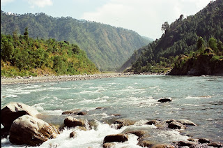
The Raavi River originates in the Himalayas in the Multhan tehsil of Kangra district of Himachal Pradesh, India.[9] It follows a north-westerly course and is a perennial river.[2] It is the smallest of the five Punjab rivers that rises from glacier fields at an elevation of 14,000 feet (4,300 m), on the southern side of the Mid Himalayas. It flows through Barabhangal, Bara Bansu and Chamba districts. It flows in rapids in its initial reaches with boulders seen scattered in the bed of the river. The Raavi River in this reach flows in a gorge with a river bed slope of 183 feet per mile (34.7 m/km) and is mostly fed by snow melt, as this region lies in a rain shadow. Two of its major tributaries, the Budhil and Nai or Dhona join 64 kilometres (40 mi) downstream from its source. The Budhil River rises in Lahul range of hills and is sourced from the Manimahesh Kailash Peak and the Manimahesh Lake, at an elevation of 4,080 metres (13,390 ft), and both are Hindu pilgrimage sites. The entire length of Budhil is 72 kilometres (45 mi) where it has a bed slope of 314 feet per mile (59.5 m/km). It flows through the ancient capital of Bharmwar, now known as Bharmour in Himachal Pradesh. During 1858–1860, the Raja of Bharmour had considered the Budhil valley as an excellent source of Deodar trees for supply to the British Raj. However, a part of the forest surrounding the temple was considered sacred and declared a reserved area. The second tributary, the Nai, rises at Kali Debi pass, and flows for 48 kilometres (30 mi), with a bed slope of 366 feet per mile (69.3 m/km), from its source at Trilokinath to its confluence with the Ravi. This valley was also exploited for its forest wealth during the English period.
Another major tributary that joins the Raavi River, just below Bharmour, the old capital of Chamba, is the Seul River from the northern direction. The valley formed by the river was also exploited for its rich timber trees. However, the valley has large terraces, which are very fertile and known as "the garden of Chamba". crops grown here supply grains to the capital region and to Dalhousie town and its surrounding areas. One more major tributary that joins the Raavi River near Bissoli is the Siawa. This river was also exploited for its forest resources, (controlled by the then Raja of Chamba) originating from the Jammu region. The valley is also formed by another major tributary that joins Seul River, the Baira-Nalla. Its sub-basin is in the Chamba district, located above Tissa. Baira drains the southern slopes of the Pir Panjal Range. The valley has an elevation variation between 5,321 metres (17,457 ft) and 2,693 meters (8,835 ft).
Tant Gari is another small tributary that rises from the subsidiary hill ranges of the Pir Panjal Range east of Bharmour. The valley formed by this stream is U-shaped with a river bed scattered with boulders and glacial morainic deposits.[11]
- Main Raavi River
The main Raavi River flows through the base of Dalhousie hill, past the Chamba town. It is at an elevation of 856 metres (2,807 ft) (where a long wooden bridge existed to cross the Raavi River).[12] It flows into the south-west, near Dalhousie, and then cuts a gorge in the Dhauladhar Range, before entering the Punjab plain near Madhopur and Pathankot. It then flows along the Indo–Pak border for 80 kilometres (50 mi) before entering Pakistan and joining the Chenab River. The total length of the river is about 725 kilometres (450 mi).[2]
Ujh River is another major tributary of the Raavi River. Its source is in the Kailash mountains at an elevation of 4,300 metres (14,100 ft), close to the Bhaderwah Mountains in Jammu district. After flowing for 100 kilometers (62 mi), it joins Raavi at Nainkot in Pakistan.
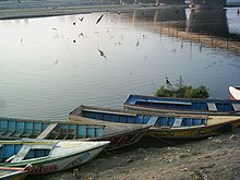
As the Raavi flows past Lahore in Pakistan (26 kilometers (16 mi) below Amritsar in India) it is called "The river of Lahore" since that city is on its eastern bank. After passing through Lahore the river takes a turn at Kamlia and then debouches into the Chenab River, south of the town of Ahmadpur Sial. On its western bank is the town of Shahdara Bagh with the tomb of Jahangir and the Tomb of Noor Jahan.
- Change of river course
According to satellite imagery studies carried out over a period of 20 years (between 1972–1973 and 1991–1993), the river coursing along the India–Pakistan border meanders substantially in the alluvial plains of the Amritsar, pathankot and Gurdaspur districts of Punjab. This has resulted in successive damage in the Indian Territory as a result of the river changing its course towards India. The reason attributed to this change in the course of the river is massive river training structures/bunds constructed by Pakistan in its part of the river, close to the old course of the river. The shift in the course of the river is reported to be 4.8 kilometers (3.0 mi) towards India.


Comments
Post a Comment
03555352726